Mapping Colonial New England: Looking at the Landscape of New England
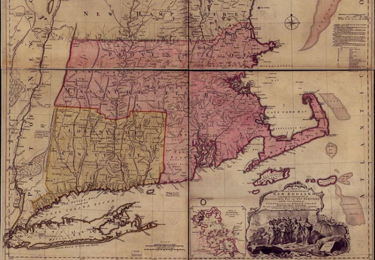
A map of the most inhabited part of New England; containing the provinces of Massachusetts Bay and New Hampshire.
"[T]his remote, rocky, barren, bushy, wild-woody wilderness, a receptacle for Lions, Wolves, Bears, Foxes, Rockoones, Bags, Bevers, Otters, and all kind of wild creatures, a place never afforded the Natives better than the flesh of a few wild creatures and parch't Indian corn incht out with Chesnuts and bitter Acorns, now through the mercy of Christ become a second England for ferilness in so short a space that it is indeed the wonder of the world..."
—Edward Johnson, The Wonder-Working Providence of Sion's Savior in New England, 1654.
English migrants created the colony of Massachusetts Bay by constructing local institutions—families, farms, churches and towns. Puritan colonists brought their European political culture with them across the Atlantic, in the form of their cherished political doctrines and even their very own ways of mapping the world. However, native occupants and English migrants had very different ideas about the land and its uses. Two major events framed a long period of political and social development: the Founding of the colony in 1630 and the outbreak of King Philip's War in 1675.
In this lesson, students learn to interpret the built environment through text and image. They also study maps as a key way of shaping territory and transmitting cultural knowledge. This lesson explores the landscape of New England as a way of understanding the contrasting ways that the Europeans and Indians understood the land and how to use it. The lesson focuses on William Wood's 1634 and William Hubbard's 1677 maps to trace how the Puritans took possession of the region, built towns, and established families on the land. How did these New England settlers interact with the Native Americans, and how can we gain information about those relationships from primary sources such as maps?
Guiding Questions
How did English migrants and American Indians view the land and its use?
How did local institutions such as towns and churches promote the success of the colony?
What were the consequences of the arrival of English colonists for American Indians and the environment?
Learning Objectives
Understand the similarities and differences between English and Native American conceptions of the land and town settlement.
Analyze how the colony of Massachusetts developed and expanded.
Examine the causes and effects of King Philip's War.
Analyze maps to determine the cultural assumptions of particular times and places.
Evaluate the consequences of the arrival of English colonists for American Indians and the environment.