Student Activity
An Early Threat of Secession: The Missouri Compromise, 1820–1821
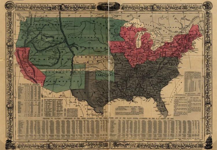
Photo caption
Political map of the United States, designed to exhibit the comparative area of the free and slave states and the territory open to slavery or freedom by the repeal of the Missouri Compromise.
The Missouri Compromise, 1820–1821 is an interactive map illustrating the geography, demography, and political division of the United States as a result of the Missouri Compromise over the issue of Slavery in 1820–21. It accompanies the EDSITEment curriculum unit: The Growing Crisis of Sectionalism in Antebellum America: A House Dividing (see in particular Lesson 1: An Early Threat of Secession: The Missouri Compromise of 1820 and the Nullification Crisis).
Note: This interactive uses Adobe Flash.
Guiding Questions and Activities
- What was the relationship between westward expansion and slavery established by the Missouri Compromise?
- Explore this map of Native American dispossession, part of a project directed by history professor Claudio Saunt. To view dispossession over time, either select the link button next to the search bar and then "See Video," or select the clock button in the bottom center toolbar to manually move through time.
- What was the relationship between westward expansion and Native American dispossession?
- For many decades, Frederick Jackson Turner's "frontier thesis" dominated interpretations of the history of the American West. You can read excerpt of his work The Frontier in American History here. Based on what you know about the Missouri Compromise and the relationship between westward expansion, slavery, and Native American dispossession, what do you think about Turner's thesis?